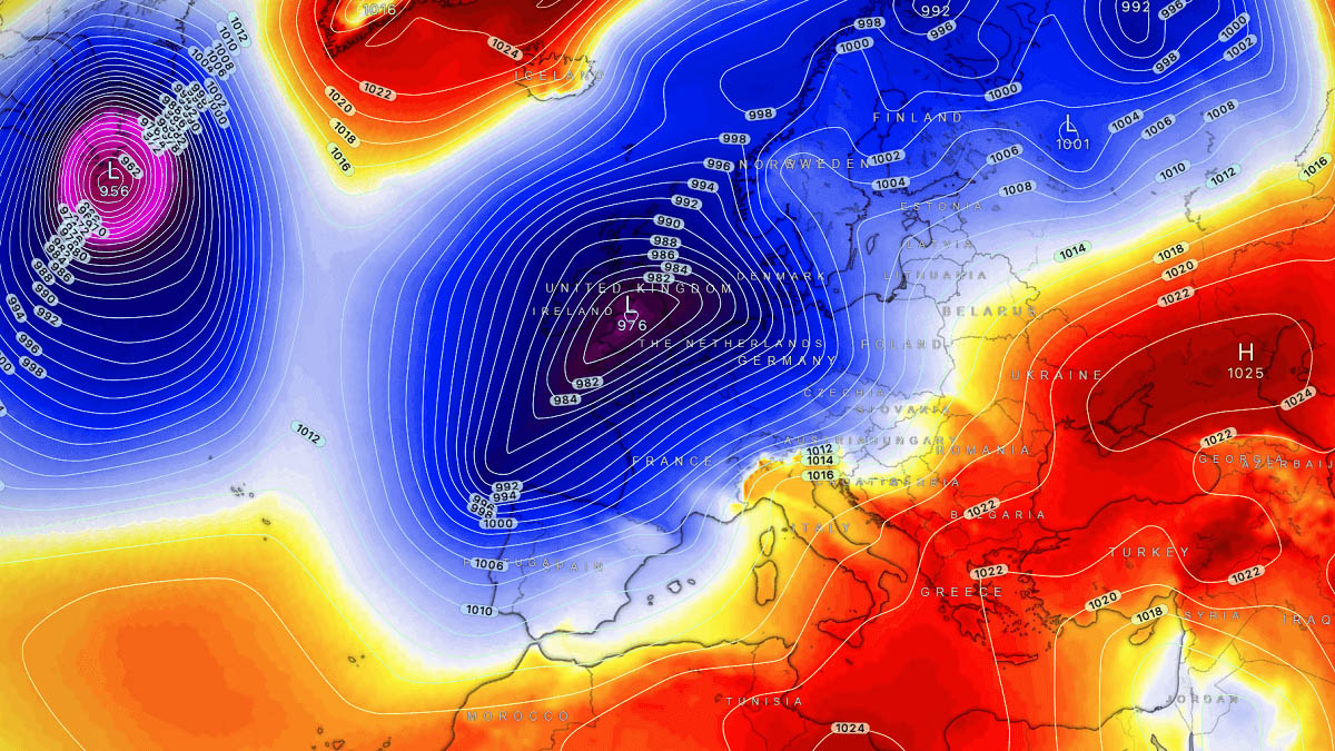
UK weather watchers are on high alert as new weather maps suggest a powerful “snow bomb” could carve a 713-mile strip across the country, dumping snow at rates of up to one inch per hour in some areas.
Forecasters say the setup is rare but increasingly familiar: bitter Arctic air pushing south colliding with moist Atlantic systems. When those two meet, the result can be intense, fast-forming snowfall that overwhelms roads, rail networks, and even gritting operations.
While not every location along the strip will see the worst conditions, the models agree on one thing — where snow does fall, it could fall hard and fast.
What exactly is a “snow bomb”?
A “snow bomb” isn’t an official meteorological term, but it’s commonly used to describe rapid, high-intensity snowfall that develops over a short period.
In this case, forecasters are tracking a low-pressure system that is expected to strengthen quickly, pulling in freezing air and creating narrow but powerful bands of snow.
These bands can:
-
Dump several centimetres of snow in just a few hours
-
Reduce visibility to near zero
-
Turn wet roads into ice sheets before gritters can react
This is why even a relatively short-lived event can cause major disruption.
Why the 713-mile strip matters
The reason this forecast is raising eyebrows is the length and continuity of the affected zone.
Instead of isolated snow showers, models show a long, narrow corridor stretching hundreds of miles where conditions could line up perfectly for heavy snow.
That means:
-
More people potentially affected
-
Longer stretches of motorway and rail at risk
-
Knock-on delays spreading far beyond snowfall areas
Even if snowfall totals don’t break records, the rate of snowfall is what creates chaos.
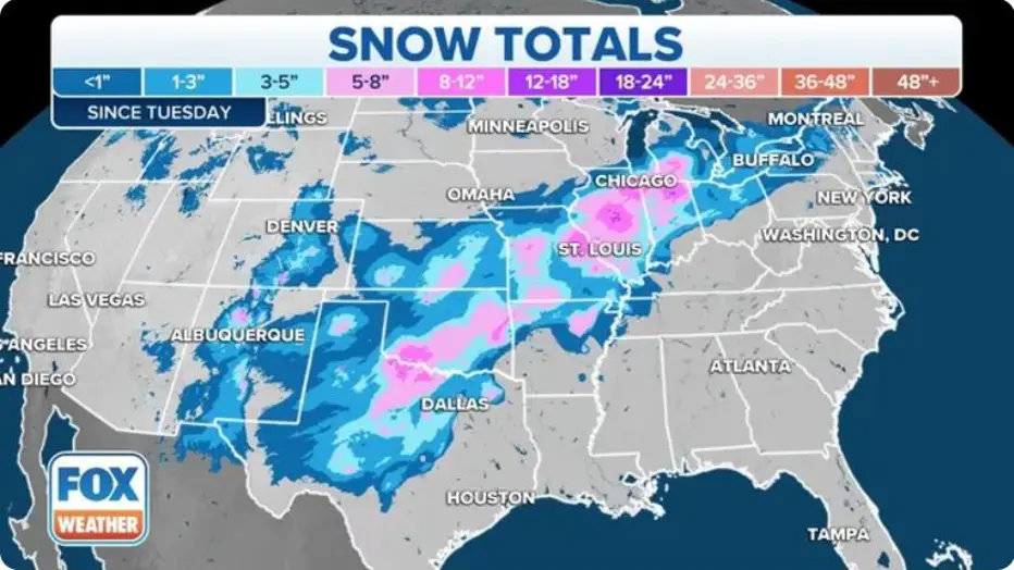
Snow Forecasted to Hit London and Other UK Counties Next Week as Heavy Snow Targets Specific Areas
Areas most at risk (based on current models)
It’s still early enough for shifts east or west, but current projections highlight a broad north-to-south swathe of the UK.
Potential impact zones
| Region type | Likely impacts | Risk level |
|---|---|---|
| Northern regions | Prolonged snowfall, drifting, rural isolation | High |
| Central belt | Heavy bursts, icy roads, commuter disruption | High |
| Midlands corridor | Rapid accumulation during peak hours | Medium–High |
| Southern uplands & higher ground | Snow turning heavy quickly | Medium |
| Coastal & low-lying areas | Rain turning to snow briefly | Low–Medium |
Important: Small shifts in temperature (even 1–2°C) could mean rain for some areas and heavy snow just a few miles away.
Snowfall rate: why one inch per hour is serious
One inch per hour may not sound dramatic — until you realise what it means in real life.
At that rate:
-
Grit becomes ineffective very quickly
-
Snow compacts into ice under traffic
-
Visibility can drop below safe driving limits
-
Emergency services struggle to reach incidents
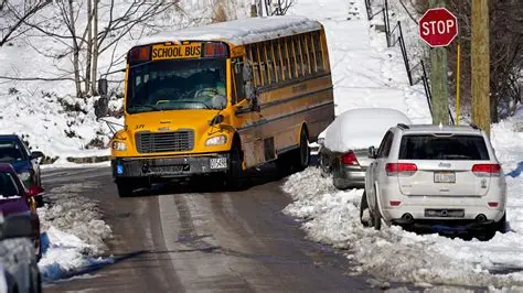
After just three hours, roads that were clear can become completely impassable.
This is why forecasters stress timing just as much as totals — snow falling during the morning commute or evening rush causes far greater disruption.
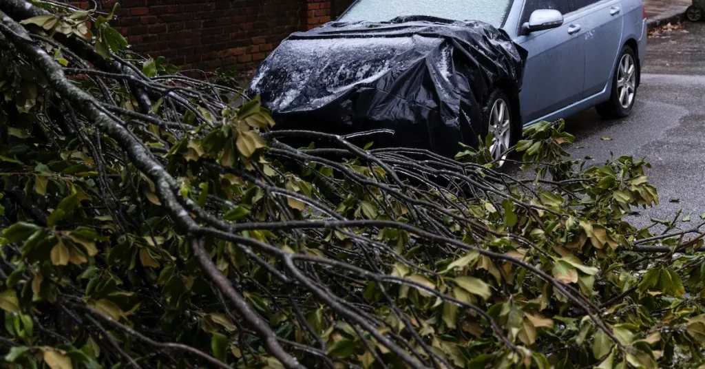
Travel and transport: what could be affected
If the forecast holds, disruption could be widespread even outside the heaviest snow zone.
Possible impacts include:
-
Motorway closures due to jack-knifed lorries
-
Rail delays from frozen points and overhead line icing
-
Airport de-icing delays and cancellations
-
School closures announced at short notice
Transport authorities usually cope well with gradual snowfall, but rapid-fire snow events are much harder to manage.
UK Weather Maps Show Six Hours of Snow Just After Christmas in England and Wales
How confident is this forecast?
Confidence is moderate but rising.
Multiple weather models are now showing:
-
Similar storm tracks
-
Comparable temperature profiles
-
Repeated signals for intense snowfall bands
However, snow forecasts in the UK are notoriously sensitive to:
-
Sea temperatures
-
Ground temperatures
-
Wind direction shifts
That means updates in the next 24–48 hours will be crucial.
How this compares to past UK snow events
This setup shares similarities with previous disruptive events where:
-
Snow fell heavily for a short time
-
Forecast totals were underestimated
-
Disruption exceeded expectations
In many past cases, it wasn’t deep snow that caused problems — it was how quickly it arrived.
What people should do now
You don’t need to panic, but being prepared helps.
Simple steps to consider:
-
Check local forecasts daily, not just national headlines
-
Avoid unnecessary travel during peak snowfall windows
-
Keep a torch, warm clothing, and phone charger handy
-
If driving, carry basic winter supplies
For businesses, flexible working and staggered start times can make a big difference.
Why snow events like this feel more disruptive now
Many people feel the UK is “worse at snow” than it used to be. Part of that perception comes from:
-
Busier roads
-
Just-in-time supply chains
-
Less tolerance for delays
-
More people commuting longer distances
Even moderate snowfall can ripple through the system much faster than in the past.
What happens next?
Forecasters will be watching:
-
Whether the cold air digs further south
-
How quickly the low pressure intensifies
-
Where the heaviest snow bands actually set up
Expect forecast maps to be refined several times before the event arrives.
Frequently Asked Questions
Is this snow bomb definitely happening?
Not guaranteed, but the risk is real. Confidence is growing, though exact locations may change.
Will this be worse than recent snowfalls?
It could be more disruptive due to the intensity and speed of snowfall rather than total depth.
Could this turn to rain instead?
Yes, especially in southern or coastal areas. Temperature margins are tight.
How long would the snow last?
Most models suggest several hours of intense snowfall, followed by lighter snow or clearing conditions.
Should schools and offices prepare for closures?
It would be sensible to plan contingencies, especially in high-risk regions.
When will forecasts be most accurate?
Around 24 hours before the event, when storm track and temperatures are clearer.
Bottom line
This isn’t guaranteed to be a historic snowstorm — but it is the kind of setup that catches people out.
A narrow 713-mile strip, snowfall rates of up to one inch per hour, and poor timing could combine to create serious disruption even if totals stay modest.
If you live anywhere near the projected zone, now’s the time to stay weather-aware and plan ahead — because when snow falls this fast, things can change very quickly.


Leave a Comment