
A potentially high-impact winter storm could affect central North Carolina this weekend, prompting WRAL to issue Weather Alert Days for both Saturday and Sunday.
The WRAL Severe Weather Center is closely tracking a developing storm system expected to impact the region on Jan. 24 and 25, 2026.
Forecast models indicate the system could bring a mix of winter precipitation types, with impacts still evolving as new data becomes available.
Meteorologists say this storm stands out compared to others this winter, making early preparation and awareness especially important.
WRAL Issues Weekend Weather Alert Days Ahead of Potential Winter Storm
WRAL has designated Saturday and Sunday as Weather Alert Days due to increasing confidence in a significant winter weather event.
The WRAL Severe Weather Center says the storm has the potential to impact a large portion of central North Carolina.
While exact precipitation types and totals remain uncertain, forecasters agree the setup warrants close monitoring.
Weather Alert Days are issued when conditions may significantly affect travel, daily routines, or public safety.
Why This Winter Storm Is Drawing Extra Attention
Meteorologists say this system is more complex than previous winter weather events this season.
“This system is probably the most interesting that we’ve seen so far this winter season,” said WRAL meteorologist Kat Campbell.
The storm involves multiple atmospheric features coming together over a short period.
Small changes in temperature profiles could determine whether areas experience snow, sleet, freezing rain, or rain.
Background: An Active Winter Weather Pattern
This storm is developing within a broader pattern that has favored winter weather across parts of the Southeast.
Repeated intrusions of cold air combined with available moisture have increased the risk of wintry precipitation.
So far this season, many systems have either lacked moisture or sufficient cold air.
Forecasters say this weekend’s storm appears to bring both ingredients together.
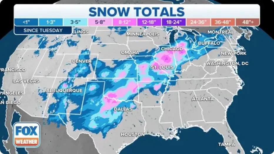
Timeline: How the Jan. 24–25 Storm May Develop
Forecast models suggest precipitation could begin sometime Saturday.
Initial precipitation may be lighter as the system organizes.
As the storm strengthens, heavier precipitation could develop later Saturday into Saturday night.
Impacts may continue into Sunday as the system moves slowly through the region.
Forecasters expect clearer trends as updated data arrives every six hours.
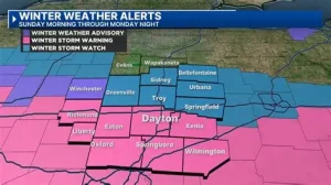
Focus on Precipitation Type Remains Critical
The primary forecast challenge is determining where different precipitation types will occur.
WRAL meteorologists have released an initial estimate showing possible zones for snow, sleet, freezing rain, and rain.
These zones are expected to shift as new model data becomes available.
Even small shifts could significantly change impacts at the local level.
Why Ice Is a Key Concern
While snow often draws the most attention, freezing rain could pose the greatest risk.
Ice accumulation can quickly make roads, bridges, and sidewalks hazardous.
Power disruptions are also more likely when ice builds up on trees and power lines.
Meteorologists emphasize that ice impacts can occur even with relatively light precipitation amounts.
Travel Impacts Could Extend Through the Weekend
Travel is expected to be one of the most affected aspects of daily life during the storm.
Road conditions could deteriorate rapidly if freezing rain or sleet develops.
Untreated roads and elevated surfaces are especially vulnerable.
Officials often advise limiting travel during periods of wintry precipitation whenever possible.
Public Reaction: Planning Ahead as Forecasts Evolve
Residents across the WRAL viewing area are already adjusting weekend plans.
Some families are moving errands and travel plans earlier in the week.
Online discussions show growing interest in precipitation maps and forecast updates.
Schools, businesses, and local agencies are monitoring developments before making decisions.
Official Messaging Emphasizes Staying Informed
WRAL meteorologists stress that the forecast will continue to evolve throughout the week.
Updated information will be provided as forecast models become more refined.
Officials encourage residents to rely on trusted local sources for the latest updates.
Weather Alert Days are intended to give the public extra time to prepare.
PROPER NEWS TABLE: Key Facts at a Glance
| Category | Details |
|---|---|
| Event | Potential high-impact winter storm |
| Location | Central North Carolina |
| Date | Jan. 24–25, 2026 |
| Who is affected | Residents, travelers, schools, businesses |
| Current status | WRAL Weather Alert Days issued |
| What readers should know | Precipitation type and impacts still evolving |
What Residents Should Do Now
Meteorologists recommend monitoring forecasts daily as the weekend approaches.
Drivers should ensure vehicles are winter-ready and plan for possible travel disruptions.
Households may consider preparing for short-term power outages if ice develops.
Staying flexible with weekend plans may help reduce risk.
What Happens Next in the Forecast Process
Forecast confidence is expected to improve as the storm draws closer.
New model data arrives approximately every six hours.
These updates will help refine precipitation types, timing, and impact areas.
Additional alerts or advisories may be issued if impacts become more certain.
FREQUENTLY ASKED QUESTIONS
When will the storm impact the area?
The storm is expected to affect the region on Saturday and Sunday, Jan. 24–25.
Why are these WRAL Weather Alert Days?
The storm has the potential to significantly impact travel and daily activities.
What types of precipitation are possible?
Snow, sleet, freezing rain, and rain are all possible depending on location.
When will the forecast become more certain?
Confidence should improve as updated data arrives throughout the week.
Should weekend plans be adjusted?
Residents are encouraged to stay flexible and monitor updates closely.
Could travel be impacted?
Yes. Travel disruptions are possible, especially if ice develops.
A potentially significant winter storm is expected to impact central North Carolina during the Jan. 24–25 weekend.
WRAL has issued Weather Alert Days for both Saturday and Sunday as forecast confidence increases.
While details are still evolving, the system has the potential to bring impactful winter weather.
Residents should stay informed, monitor forecast updates, and watch for additional advisories as the weekend approaches.


Leave a Comment