Introduction
Southeast Michigan is facing a two-day stretch of dangerous winter weather that could impact travel, safety, and daily routines.
Forecasters warn that strong, damaging winds on Monday will be followed by dangerously cold windchills early Tuesday morning, creating hazardous conditions across the region, including the Detroit metro area.
The combination of powerful gusts and Arctic air raises concerns for power outages, difficult driving conditions, and frostbite risk, especially during the morning commute.
Residents are being urged to prepare now as weather conditions rapidly worsen.
Strong Winds Expected Across Southeast Michigan Monday
A fast-moving winter system is expected to bring strong to potentially damaging winds across Southeast Michigan on Monday.
Wind gusts could reach 40 to 55 mph, particularly in open areas and along major roadways. These winds may be strong enough to down tree limbs, damage power lines, and cause scattered outages.
High-profile vehicles, including trucks and SUVs, may experience difficult driving conditions on east-west roads.
Wind Advisories Issued for the Region
The National Weather Service has issued wind advisories for parts of Southeast Michigan, warning residents to secure loose outdoor items and use caution while traveling.
Officials say the strongest winds are expected from late morning through early evening Monday, coinciding with peak daytime activity.
Why These Winds Are So Powerful
The strong winds are being driven by a tight pressure gradient behind a departing storm system.
As colder air rushes in to replace warmer air, wind speeds rapidly increase. This type of setup is common during winter but can become dangerous when paired with falling temperatures.
Meteorologists say wind speeds of this magnitude can significantly increase the risk of property damage and travel disruptions.
Timeline: What to Expect Hour by Hour
-
Monday morning: Winds increase rapidly across Southeast Michigan
-
Monday afternoon: Peak wind gusts between 40–55 mph
-
Monday evening: Winds slowly diminish but remain gusty
-
Late Monday night: Temperatures plunge
-
Early Tuesday morning: Dangerous windchills develop
The most hazardous period for cold exposure is expected before sunrise Tuesday.
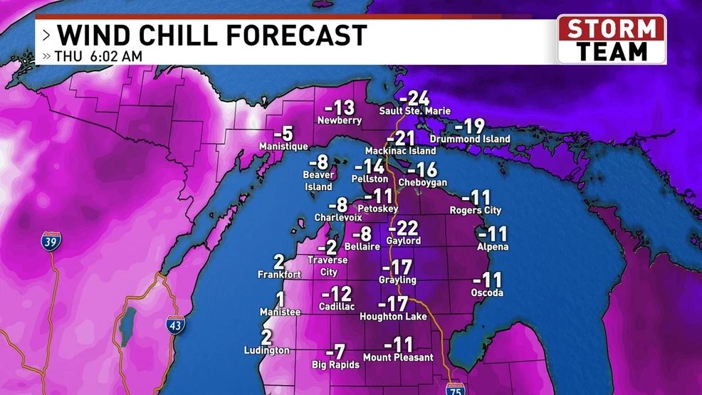
Dangerous Windchills Arrive Tuesday Morning
Behind Monday’s wind event, an Arctic air mass will settle over the region.
Actual air temperatures may drop into the single digits, but strong lingering winds will drive windchills well below zero, potentially reaching -15°F to -25°F in some locations.
At these levels, frostbite can occur on exposed skin in as little as 15–30 minutes.
Who Is Most at Risk
The dangerous windchills pose the greatest risk to:
-
People without adequate heat
-
Outdoor workers
-
Children waiting for school transportation
-
Elderly residents
-
Pets left outdoors
Officials strongly advise limiting outdoor exposure Tuesday morning whenever possible.
Travel and Power Outage Concerns
Strong winds Monday increase the risk of downed power lines and scattered outages, particularly in areas with weakened trees.
Drivers should be alert for debris on roadways and be prepared for sudden crosswinds, especially on bridges and overpasses.
Utility crews are expected to be on standby in case repairs are needed.
Public Safety Guidance from Officials
Local emergency managers recommend several precautions:
-
Secure trash bins, patio furniture, and decorations
-
Charge phones and backup batteries
-
Dress in multiple layers Tuesday morning
-
Protect pets and bring them indoors
-
Check on vulnerable neighbors
The National Weather Service continues to monitor conditions and will issue additional advisories if needed.
What Happens Next
Temperatures are expected to remain below normal through midweek, though winds should gradually weaken after Tuesday morning.
Another weather system later in the week could bring additional changes, including snow chances or renewed cold, depending on storm track.
Residents are encouraged to stay alert for updated forecasts.
Key Facts at a Glance
| Detail | Information |
|---|---|
| Event | Strong winds and dangerous windchills |
| Location | Southeast Michigan |
| Wind threat | Monday |
| Coldest period | Early Tuesday morning |
| Wind gusts | Up to 55 mph |
| Windchills | As low as -25°F |
| Current status | Advisories in effect |
| What readers should know | Prepare for power outages and frostbite risk |
Frequently Asked Questions
How strong will the winds be on Monday?
Wind gusts may reach 40–55 mph in parts of Southeast Michigan.
Will power outages happen?
Scattered outages are possible due to falling tree limbs and power lines.
How cold will it feel Tuesday morning?
Windchills could drop to between -15°F and -25°F.
Is frostbite a concern?
Yes. Frostbite can occur within 15–30 minutes on exposed skin.
Should schools delay or close?
No announcements yet, but families should monitor local updates.
When will conditions improve?
Winds ease Tuesday, but cold temperatures persist through midweek.
Closing
Southeast Michigan is entering a high-impact winter weather period marked by strong winds Monday and dangerous cold early Tuesday.
Residents should prepare now, limit outdoor exposure during peak cold, and monitor official weather updates as conditions continue to evolve.


Leave a Comment