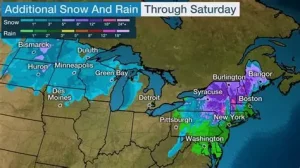
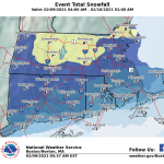
A powerful winter storm is gearing up to hit Massachusetts and much of New England this weekend, with forecasters warning of heavy snow, bitter cold, and risks of widespread power outages.
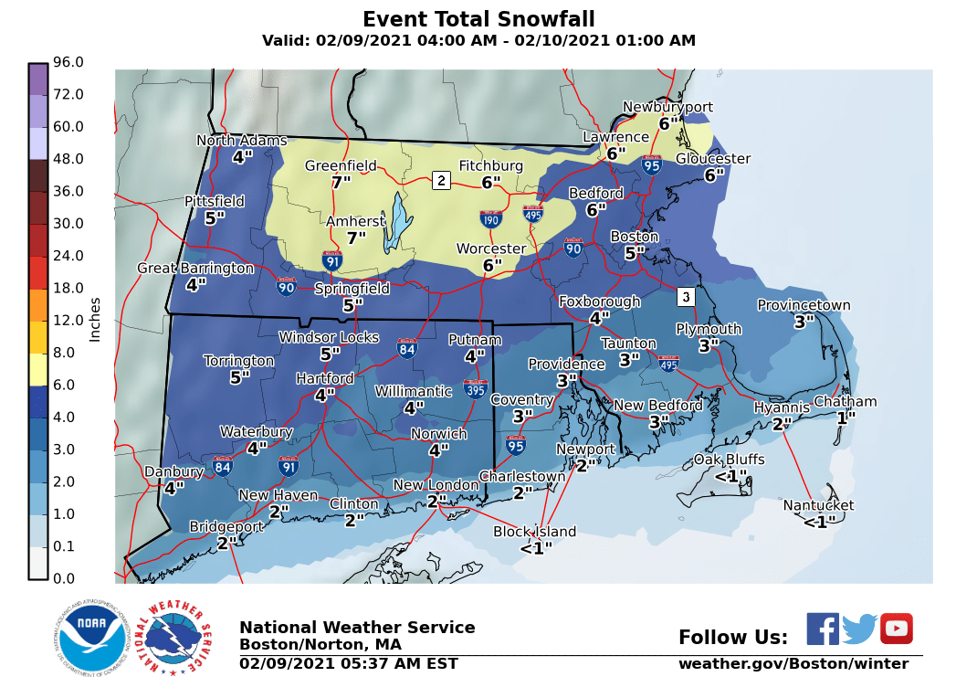
Some areas of the state could see 12 to 24 inches of snow as the storm sweeps in, beginning around midday Sunday and potentially lasting into late Monday.
This system is part of a larger winter storm expected to affect much of the eastern United States, raising concerns about travel disruptions, school closures and stress on infrastructure.
For many communities in Massachusetts, how and when the snow falls could make this one of the season’s most disruptive storms.
Key Facts at a Glance
| Event | Location | Date | Who Is Affected | Current Status | What Readers Should Know |
|---|---|---|---|---|---|
| Major winter storm | Massachusetts & New England | Sunday–Monday | Residents, commuters, utilities | Storm developing | Snowfall could reach 1–2 feet |
| Heavy snow | Central & eastern Mass. | Sun afternoon–Mon | Drivers, travelers | Expected | Snow may fall for 24+ hours |
| Power outage risk | Statewide | Sun–Mon | Households, businesses | Elevated | Heavy snow + wind could down lines |
| Dangerous cold | New England | Late weekend | General public | Forecast | Bitter wind chills possible |
A Large Winter System Coming Together
Meteorologists say a strong low-pressure system will track up the East Coast, colliding with cold air already in place over New England.
That setup favors heavy, prolonged snowfall. Some models show snowfall rates exceeding 1 to 2 inches per hour, especially late Sunday into early Monday.
Small shifts in the storm’s path could change totals, but confidence is increasing that Massachusetts will be one of the hardest-hit states.
“The environment is set up for a significant coastal storm,” said Alan Dunham, chief meteorologist at the Weather Prediction Center. “We could see widespread snow for more than a day.”
When the Snow Is Expected
Sunday (Midday to Evening)
Snow should begin across much of Massachusetts around late morning to early afternoon. Roads may deteriorate quickly as snow becomes heavier.
Visibility could drop sharply as flakes pile up, particularly on untreated surfaces.
Sunday Night
This is likely to be the most intense window. Snow will likely fall more consistently, and winds may strengthen enough to cause blowing and drifting.
Monday
Snow may taper in the morning but could linger into the afternoon or evening depending on location. Cold temperatures and drifting snow may slow cleanup efforts.
How Much Snow Could Accumulate
Current forecasts suggest:
-
Most of Massachusetts: 12–24 inches
-
Some higher-impact zones: Toward the upper end of that range
-
Coastal areas: Possibly slightly less if brief mixing occurs
The heavy, wet nature of the snow raises concerns about downed trees and power lines, especially where winds gust.
“Wet snow adheres to branches and wires,” said Brian Hurley, a senior meteorologist with the National Weather Service in Taunton, Massachusetts. “That combination, with winds, increases the chance of interruptions to electricity.”
Power Outages and Infrastructure Stress
Utility crews are preparing for a surge in outage response as snow begins. Heavy snow loading on trees and lines can lead to breakage, and wind can push weak limbs over power infrastructure.
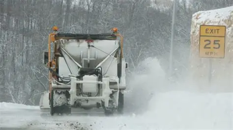
Road crews are staging plows and salt trucks statewide. However, crews have warned that secondary roads and residential streets could remain difficult to travel on for much of the storm.
Emergency management officials advise residents to prepare for potential outages by ensuring devices are charged and heaters or alternative heat sources are ready.
Official Warnings and Preparations
The National Weather Service has issued winter storm watches and warnings across much of Massachusetts and surrounding states.
Local public works departments say they are braced for extended snow removal operations.
State transportation officials have urged drivers to avoid travel once snowfall starts in earnest.
Public Reaction: Preparations Underway
Across Massachusetts, residents have responded to the forecast by stocking up on essentials.
Grocery stores saw heavy traffic Friday and Saturday as people bought groceries, ice melt and shovels.
At hardware stores, sales of generators, snow blowers and snow removal tools rose as homeowners prepared for several days of snow.
Social media is also buzzing with posts about travel plans, school closures and airline updates. At Logan International Airport, travelers are watching for delays and cancellations as Sunday approaches.
After the Snow Ends
Snow cleanup could take time even after the storm ends. High totals would mean snowbanks along roads and slower plowing in neighborhoods.
Cold temperatures overnight could lead to refreezing, making travel hazardous even after main roads are cleared.
Some communities could deal with lingering impacts for days, including icy sidewalks and bridges.
Frequently Asked Questions
How much snow can Massachusetts expect?
Many areas could see 1 to 2 feet of snow by the time the storm moves out.
When does the snow start?
Snow is expected to begin around midday Sunday.
How long will the storm last?
Snow could continue into late Monday in some locations.
Are power outages likely?
Yes. Heavy snow and wind increase the risk of outages.
Should people avoid travel?
Officials recommend avoiding travel once snow becomes heavy.
Could schools close Monday?
Closures and delays are possible, particularly if snow continues into Monday morning.
Does this impact other states?
Yes. The storm is expected to affect much of the eastern U.S.
What to Watch Next
Forecasters will continue refining snowfall totals and timing as the storm gets closer.
Residents should stay updated with official weather alerts and local emergency information through the weekend.
In the coming days, road conditions, power restoration and cleanup efforts will be major focuses as communities work through the storm’s impacts.


Leave a Comment