A mix of winter weather is poised to create hazardous conditions overnight across parts of Tennessee, Georgia, Alabama, and the southern Appalachians. Ice accumulations are possible before the precipitation shifts to heavy rain on Sunday.
Forecasters say the main concern is freezing rain developing Saturday evening and lasting into the early hours of Sunday. Slight temperature differences could determine whether areas see harmless rain or a coating of ice capable of causing power outages and slick roads.
Drivers, hikers, and utility crews are being warned to prepare for treacherous travel, particularly in higher elevations where colder air will linger longer.
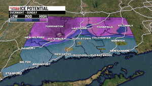
Ice Storm Warning Covers Much of the Region
Most of the area is under an Ice Storm Warning through Sunday, highlighting the risk of significant ice accumulation. The warning includes the Cumberland Plateau, Walden Ridge, metro mountain communities, and portions of north Georgia. Valley areas may see lighter ice or mainly rain, though temperatures are expected to hover near freezing for several hours.
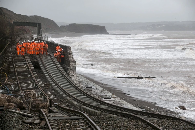
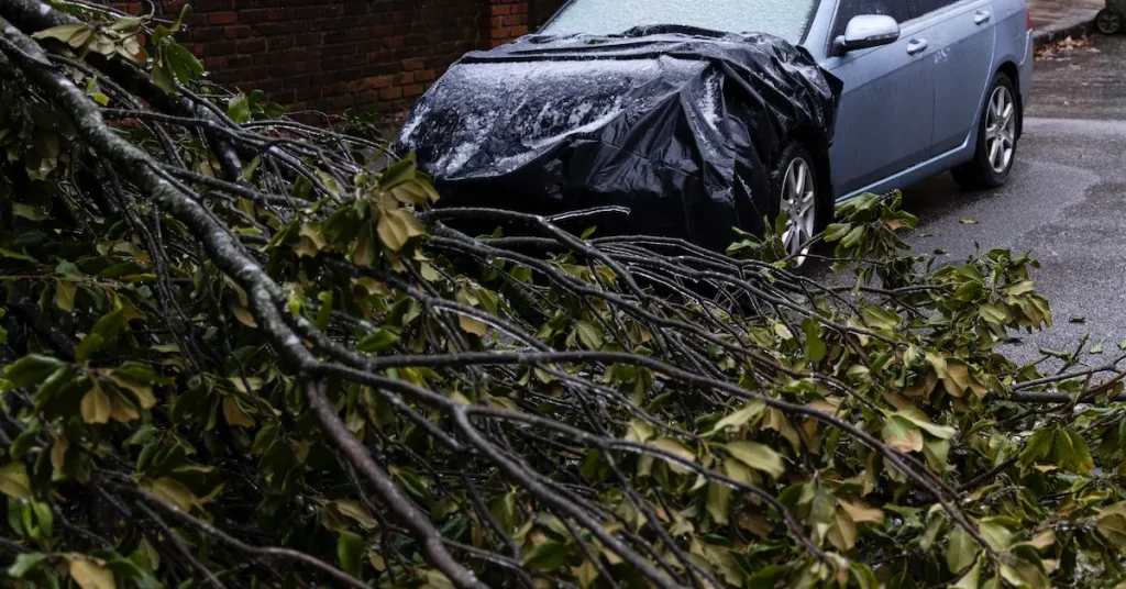
Ice storms are especially dangerous because impacts can persist even after precipitation stops. Tree limbs and power lines coated in ice remain vulnerable, sometimes snapping hours later under the weight.
“The weight of ice can make even minor accumulation hazardous,” said meteorologist Jenna Harper of the National Weather Service office in Nashville. “Roads, bridges, and utility lines are all at risk, so caution is essential.”
Key Facts at a Glance
| Event | Location | Date | Who Is Affected | Current Status | What Readers Should Know |
|---|---|---|---|---|---|
| Ice Storm Warning | TN, GA, AL, southern Appalachians | Through Sunday | Residents, drivers, utilities | Active | Freezing rain possible overnight |
| Snow and sleet burst | Cumberland Plateau, Walden Ridge | Sunday morning (8 AM–1 PM) | Commuters, travelers | Expected | Light accumulations up to 0.5” |
| Heavy rain | Region-wide | Sunday morning onward | Flood-prone areas | Forecast | Rain follows wintry mix |
Timeline: How Conditions Are Expected to Unfold
Saturday evening to early Sunday morning (7 PM – 3 AM)
Freezing rain will be the primary concern. In colder spots, rain will freeze on contact. Higher elevations could see the most significant ice, while some valleys may stay just warm enough for rain.
Sunday morning (8 AM – 1 PM)
A burst of snow and sleet is possible in parts of the Cumberland Plateau and Walden Ridge. Accumulations are expected to be light, but roads could become slippery during the morning commute.
Sunday afternoon
Warmer air pushes north, turning precipitation to rain for most areas. Heavy rainfall may lead to localized flooding, especially where ice or snow has already limited drainage.
Expected Ice Accumulations by Region
-
Plateau, metro mountains, north Georgia mountains: Up to 0.50 inches
-
Valley locations in TN, GA, AL: Generally 0.10–0.25 inches, some areas mostly rain
-
Blue Ridge Mountains: Up to 0.25 inches
Even a quarter-inch of ice can make roads treacherous and cause tree limbs or power lines to fail.
“People often underestimate ice,” said NWS forecaster Robert Kent. “Unlike snow, ice can form a glaze that makes travel instantly hazardous.”
Why Ice Storms Are Particularly Dangerous
Freezing rain creates hazards that snow rarely does. Roads can become slick within minutes. Tree limbs and power lines can bend or snap under the weight, sometimes long after the precipitation ends. Clean-up and recovery often take longer than for snow.
Emergency managers emphasize preparation. “Even small amounts of ice can have major consequences,” said Harper. “Take warnings seriously and stay off the roads if possible.”
Official Guidance and Safety Tips
Officials urge residents to avoid travel overnight and early Sunday if freezing rain develops. Drivers should slow down, steer clear of bridges and overpasses, and remain alert for sudden ice patches.
Utility crews are on standby in areas prone to ice-related outages. Residents are encouraged to charge devices, secure outdoor items, and stay cautious around trees and power lines.
Public Reaction: Concern Over Roads and Power
Across the region, people are monitoring forecasts closely. Many are worried about overnight travel and Sunday morning commutes, especially in higher elevations. Social media posts show concern over slippery back roads, school schedules, and power reliability.
Local agencies have warned that even minor ice accumulation can have a significant impact given the narrow temperature window for freezing.
What Happens After the Ice
Once temperatures rise, the wintry threat will shift to rain. Heavy rainfall Sunday could create localized flooding in areas where ice or snow slows drainage. Low-lying and flood-prone zones should remain vigilant.
Even after rain begins, damage from ice may linger, including downed branches and slick surfaces.
Frequently Asked Questions
When is the highest risk for ice?
Between 7 PM Saturday and 3 AM Sunday.
Who is most at risk for significant icing?
Higher elevations: Cumberland Plateau, Walden Ridge, and north Georgia mountains.
Will everyone see ice?
No. Some valley areas may see mainly rain if temperatures remain above freezing.
How much ice is dangerous?
0.10 inches can make roads slick; 0.25 inches or more may impact power lines.
What happens after Sunday morning?
Wintry precipitation changes to rain as temperatures rise.
Should travel be avoided?
Yes—especially overnight and during early Sunday hours.What to Watch Going Forward
Temperature trends overnight will determine whether residents see ice or just cold rain. Even a small change can alter road conditions dramatically.
Residents should monitor local forecasts, follow Ice Storm Warnings, and prepare for rapidly changing conditions through Sunday morning.


Leave a Comment