Beneath the vast landscapes of Africa, an invisible force is quietly reshaping the continent’s future. Over the course of millions of years, the African continent is literally splitting apart at its seams. This isn’t a catastrophic event happening overnight, but rather a slow, deliberate geological process that will ultimately transform Earth’s geography in ways we can scarcely imagine today. Scientists around the world are closely monitoring this fascinating phenomenon, gathering evidence that paints a remarkable picture of our planet’s dynamic nature.
Understanding the East African Rift System
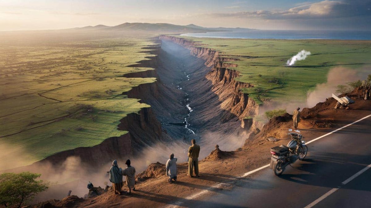
The primary location where this continental separation is occurring stretches across eastern Africa in what geologists call the East African Rift System. This massive geological feature extends from the Afar Triangle in Ethiopia southward through Kenya, Tanzania, and into Mozambique. The rift represents a zone where the African tectonic plate is actively pulling itself apart, driven by deep mantle convection currents beneath the Earth’s crust.
The East African Rift is not a single crack but rather a complex network of faults and fractures that are gradually widening. In some areas, the rift valley has plunged over 9,000 feet below the surrounding terrain, creating some of Africa’s most dramatic landscapes. These valleys are home to some of the continent’s most iconic features, including Lake Tanganyika, Lake Victoria, and numerous volcanic peaks.
The Geological Mechanics Behind Continental Rifting
The process driving Africa’s separation involves fundamental principles of plate tectonics. Deep beneath the African continent, hot material from the Earth’s mantle rises toward the surface. This upwelling of molten rock creates immense pressure, which forces the overlying continental crust outward in different directions. Over geological timescales, this outward pressure gradually weakens the crust and causes it to stretch and thin.
As the continental crust stretches, it becomes increasingly brittle and fractures along predetermined weak zones. The East African Rift System follows one such zone of crustal weakness. The stretching motion causes sections of the continent to subside downward, creating the characteristic rift valleys we observe today. Simultaneously, volcanic activity along the rift releases material from the mantle, bringing new material to the surface.
This process is remarkably slow by human standards. Currently, the African continent is separating at a rate of approximately one to two centimeters per year in certain locations. While this might seem negligible, over millions of years it accumulates into continental-scale transformations. Geological evidence suggests that if this process continues at current rates, Africa could eventually split into two distinct continents within the next 50 to 100 million years.
Evidence Supporting the Continental Split
Scientists have compiled compelling evidence for Africa’s ongoing separation through multiple research methods. Satellite technology, particularly GPS measurements, provides precise data about crustal movement. Scientists strategically place GPS stations across the rift zone and track subtle changes in their positions over time. These measurements consistently show that the ground on either side of the rift is moving apart at measurable rates.
Seismic data provides additional confirmation. Earthquakes frequently occur along the rift as the crust ruptures under tension. The pattern and characteristics of these earthquakes reveal the direction and magnitude of stress acting on the rocks. Scientists analyze thousands of seismic events to map the precise nature of the rifting process and predict future geological changes.
Geological fieldwork has revealed distinctive rock formations and structures that confirm the rifting hypothesis. Fault scarps—steep cliffs created where rock layers offset along fault lines—are visible throughout the rift zone. Mineral assemblages in rocks indicate changing pressure and temperature conditions consistent with crustal extension and thinning. Additionally, the presence of extensive volcanic deposits along the rift system confirms active mantle material reaching the surface.
The Future Ocean: When Water Meets the Rift
As the rifting process continues over geological timescales, a fascinating scenario emerges. Eventually, the separating continental plates will create a depression that extends below sea level. When this occurs, seawater will gradually flood the rift valley, transforming it into a new ocean basin. This process has historical precedent: the Red Sea and the Atlantic Ocean both originated as continental rifts that eventually filled with seawater.
The creation of a new ocean would be among the most significant geographical transformations in Earth’s history. The eastern portion of Africa would become a separate continental fragment, while the western portion would remain attached to the larger African continent. Over tens of millions of years, these fragments would drift apart due to seafloor spreading, creating an ocean basin separating them.
The timeline for this transformation is extraordinarily long by human standards. Most estimates suggest that complete separation and ocean formation would require 50 to 100 million years under current geological conditions. This timescale is approximately twice as long as the period since dinosaurs went extinct, illustrating just how slowly continental processes operate.
Current Impacts and Observable Changes
Despite the slow rate of change, the ongoing rifting process already affects Africa’s geography and inhabitants. The rift valley’s steep walls create distinct climate zones, with different rainfall patterns on either side of the valley. This geographical feature has profoundly influenced the evolution of African wildlife and human societies throughout history.
Recent research has documented visible changes in the landscape that can be attributed to the rifting process. In 2018, a particularly dramatic ground fissure opened across parts of Kenya, visibly demonstrating the active pulling-apart of the continent. While such sudden surface ruptures make for impressive visual evidence, they represent just momentary releases of the continuous stress accumulating beneath Africa’s surface.
Why This Matters for Our Understanding of Earth
The splitting of Africa demonstrates that our planet remains geologically dynamic and constantly evolving. This ongoing process provides scientists with a natural laboratory for studying continental rifting, plate tectonics, and the fundamental processes that shape Earth’s surface. Understanding these mechanisms helps geologists predict volcanic activity, anticipate earthquakes, and comprehend how continents form and move.
The East African Rift System represents one of Earth’s most important geological laboratories, offering insights into processes that have shaped planetary evolution for billions of years. As technology improves and monitoring becomes more sophisticated, scientists will continue unraveling the mysteries of how continents break apart and new oceans are born.
Africa’s gradual separation into two continents is a testament to the incredible forces operating beneath our feet, constantly reshaping the world we inhabit—a transformation unfolding at a pace that reminds us of Earth’s incomprehensible age and the spectacular geological changes that define our dynamic planet.


Leave a Comment