Snow is all but guaranteed for Fayetteville and the Sandhills this weekend. The only question now is how much.
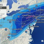
According to the National Weather Service in Raleigh, confidence is high that significant snowfall will impact central North Carolina, including Cumberland County, beginning late Friday night.
A winter storm warning, cold weather advisory, and extreme cold watch are all in effect for Cumberland and surrounding counties as the system moves in.
Forecasters warn that travel conditions could become dangerous from Friday night through early next week due to heavy snow and the risk of black ice.
Winter Storm Warning Covers Cumberland County and Surrounding Areas
The National Weather Service issued a winter storm warning for Fayetteville, Cumberland County, and much of the Sandhills region ahead of a powerful winter system expected to impact central North Carolina.
In a 6 a.m. Friday weather briefing, forecasters said snowfall is expected to be widespread and potentially heavy across the region.
In addition to the storm warning, a cold weather advisory and extreme cold watch are also in effect for the weekend.
Officials say the combination of snow, cold temperatures, and lingering ice could create prolonged hazards.
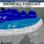
How Much Snow Is Expected in Fayetteville and Nearby Counties
Forecast confidence continues to increase regarding snowfall totals.
The National Weather Service says central North Carolina could see between 4 and 8 inches of snow, with some locations likely exceeding that range.
For Cumberland County, the most likely snowfall total is 8 to 10 inches.
Neighboring counties are also expected to see significant accumulation:
-
Harnett County: 6 to 8 inches
-
Sampson County: 8 to 10 inches
-
Moore County: 6 to 8 inches
On the high end, which forecasters say is less likely, Cumberland County could receive up to 14 inches of snow.
On the low end, also considered less likely, totals could be closer to 3 inches.
Snowfall Timing: When the Storm Is Expected to Hit
Snowfall is expected to begin late Friday night or early Saturday morning, according to the latest forecast.
Snow will continue through much of Saturday and into Sunday morning before tapering off.
Forecasters say the most intense snowfall could occur during overnight hours, increasing the risk for slick roads and reduced visibility.
Cold temperatures following the storm may allow snow and ice to linger well into early next week.
Interstate 95 Corridor Could See Heaviest Snow
The National Weather Service says favored locations for the highest snowfall totals include areas along the Interstate 95 corridor.
This zone extends from eastern North Carolina westward toward the Triangle region.
Cumberland County sits squarely within this corridor, increasing the likelihood of higher snow totals.
Forecasters say banding within the storm could lead to sharp differences in accumulation over short distances.
Travel Impacts Expected Through the Weekend and Beyond
Travel conditions are expected to deteriorate quickly once snowfall begins.
Roads could become snow-covered overnight Friday, with hazardous conditions continuing through Saturday.
Black ice may become a significant concern after the snow ends as temperatures remain below freezing.
Officials warn that conditions could remain dangerous even after plowing operations begin.
Emergency Preparations Underway
A state of emergency has been declared ahead of the storm for the Cumberland County area.
Local officials confirmed that shelters are opening to assist residents who may need a warm place to stay during the extreme cold.
Emergency management agencies urge residents to complete preparations before snowfall begins.
That includes limiting travel, stocking supplies, and checking on vulnerable neighbors.
Snow Probabilities Show High Confidence
Forecast probabilities underscore the high level of confidence in snowfall.
For Cumberland County:
-
1 inch or more of snow: 100% probability
Forecasters say this level of certainty is uncommon and reflects strong agreement among weather models.
Updates will continue as the storm develops.
KEY FACTS SUMMARY
| Event | Winter storm impacting Fayetteville |
|---|---|
| Location | Cumberland County and Sandhills region |
| Date | Late Friday night through Sunday |
| Who is affected | Residents, travelers, emergency services |
| Current status | Winter storm warning in effect |
| What readers should know | Heavy snow and icy roads likely |
FREQUENTLY ASKED QUESTIONS
Will it definitely snow in Fayetteville?
Yes. The National Weather Service says snowfall is expected with high confidence.
How much snow is expected in Cumberland County?
The most likely total is 8 to 10 inches.
When will snow start?
Late Friday night or early Saturday morning.
How long will snow last?
Snow could continue into Sunday morning.
Will travel be dangerous?
Yes. Snow and black ice could impact roads through early next week.
Is extreme cold expected after the snow?
Yes. Cold temperatures may allow ice to linger.
CLOSING
A significant winter storm is expected to impact Fayetteville and the Sandhills this weekend, bringing heavy snow, extreme cold, and hazardous travel conditions.
Residents are encouraged to finalize preparations, avoid unnecessary travel, and monitor updates from the National Weather Service as conditions evolve.


Leave a Comment